Oil and Gas Exploration
Methods and Application
- English
- ePUB (mobile friendly)
- Available on iOS & Android
About this book
Oil and Gas Exploration: Methods and Application presents a summary of new results related to oil and gas prospecting that are useful for theoreticians and practical professionals. The study of oil and gas complexes and intrusions occurring in sedimentary basins is crucial for identifying the location of oil and gas fields and for making accurate predictions on oil findings.
Volume highlights include:
- Advanced geophysical techniques for achieving hydrocarbon exploration efficiency from beneath the Earth
- Discussion of theoretical and practical approaches in solving problems related to exploring and mining new oil and gas deposits
- New geological concepts for predicting potential hydrocarbon targets
- Novel methods of control of the outworking of these deposits using different geophysical methods, significant for optimization of mining hydrocarbon and carbonate deposits
- Estimation of the degree of outworking of oil and gas deposits, to facilitate the use of space - time monitoring of different kinds of fields
- Analysis of exploration data by an efficient processing system, based on strong methods proven mathematically
Oil and Gas Exploration is a valuable resource for exploration geophysicists, petroleum engineers, geoengineers, petrologists, mining engineers, and economic geologists, who will gain insights into exploring new methods involved in finding natural resources from our Earth. Read an interview with the editors to find out more:
https://eos.org/editors-vox/where-and-how-can-we-find-new-sources-of-oil-and-gas
Tools to learn more effectively

Saving Books

Keyword Search

Annotating Text

Listen to it instead
Information
1
EXPERIENCE OF REGIONAL PREDICTION OF HYDROCARBON DEPOSITS PROSPECTING IN THE VICINITY OF URAL OIL AND GAS PROVINCES
Abstract
This chapter is devoted to investigating oil and gas content in the Ural region according to the position of the Earth’s crust deep structure. A significant volume of deep seismic soundings was provided in the Ural region by the Bagenov geophysical expedition, by the Institute of Geophysics (Ural Branch of Russian Academy of sciences), and by the Center of Regional Geophysical Research (GEON) during some decades. We have elaborated a new technology of seismic geomapping, based on new model conceptions about the structure of the upper part of lithosphere. We supplement the base of seismic research by the geological data (information about the oil and gas content of the region), the data of super deep boreholes, and area gravimetric data. That allowed us to construct a geological‐geophysical fault‐block volume model of the lithosphere (up to 80 km), to provide the tectonic mapping according to these cuts: the surface of ancient crystalloid crust and the main seismic geological surface M. On the basis of the obtained information compared with the data of hydrocarbon deposits location, new depth criteria of forecasting deposits in new regions and objects have been developed. We can assign some examples of positive forecasting. They are the Kueda region (south of Perm region) and the region of the town Khanti‐Mansyisk.
1.1. Introduction
1.1.1. Some Information About Oil‐Gas‐Reserves of Ural’s Region and Their Geological Environment
1.2. Method of Information Analysis for the Regional Prediction
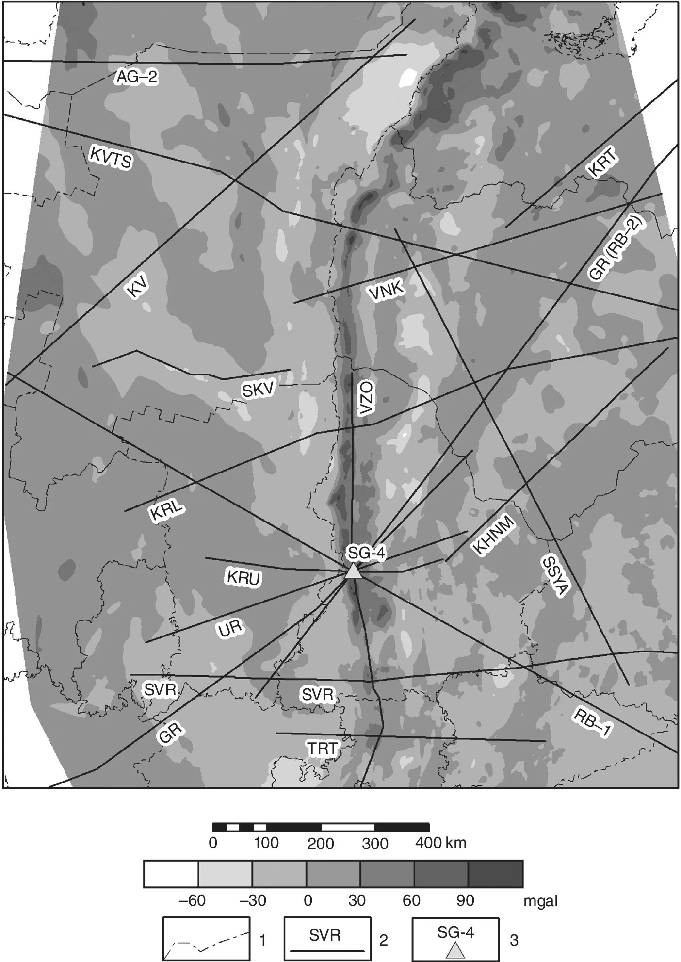
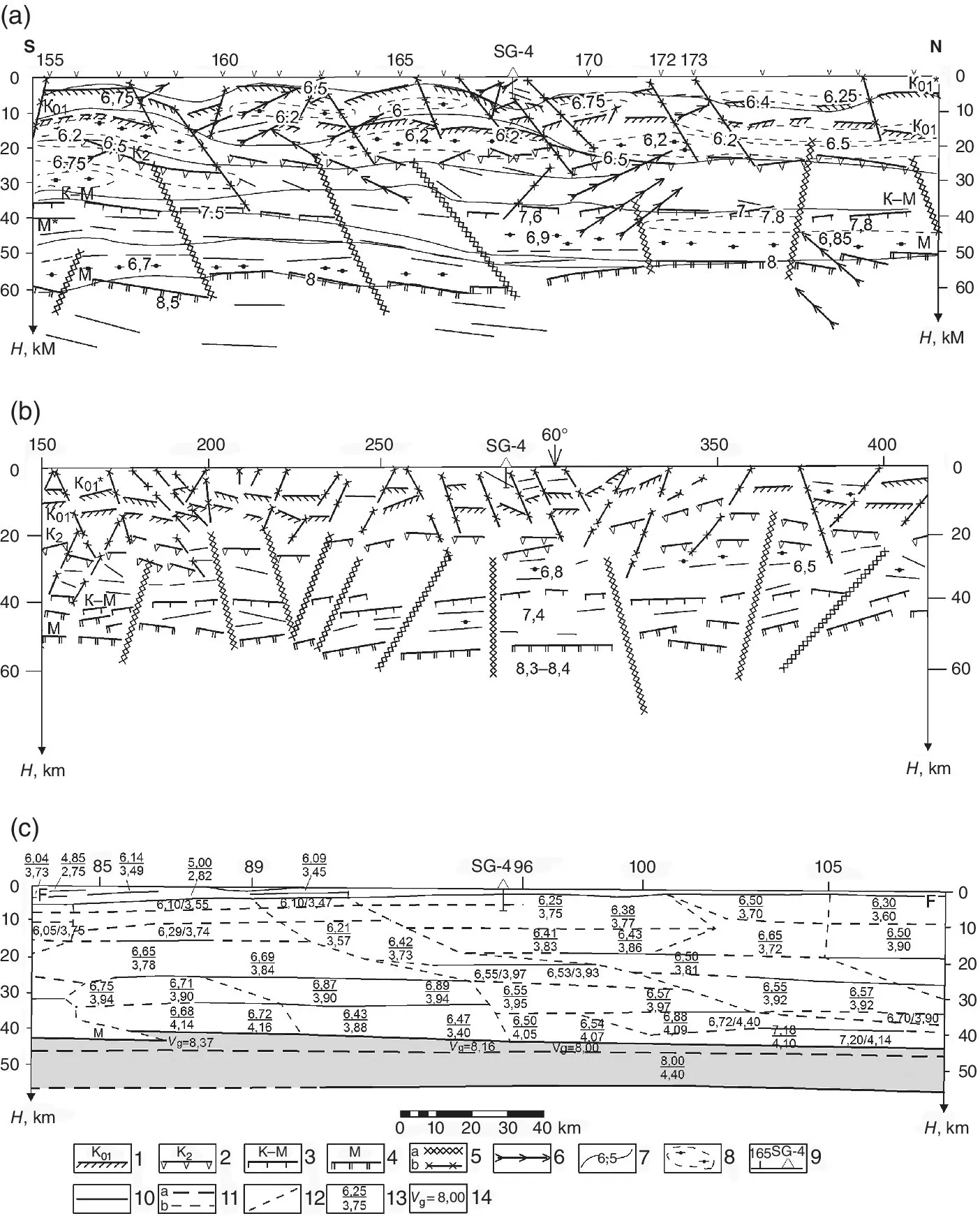
Table of contents
- Cover
- Title Page
- Table of Contents
- CONTRIBUTOR LIST
- PREFACE
- ACKNOWLEDGMENTS
- 1 EXPERIENCE OF REGIONAL PREDICTION OF HYDROCARBON DEPOSITS PROSPECTING IN THE VICINITY OF URAL OIL AND GAS PROVINCES
- 2 WAVELET‐BASED MULTIFRACTAL ANALYSIS OF LANDSAT 8 IMAGES: APPLICATIONS TO MINERAL DEPOSITS AND SHALE GAS RESERVOIRS
- 3 SEISMIC SIGNAL DENOISING USING EMPIRICAL MODE DECOMPOSITION
- 4 A LITHOLOGICAL SEGMENTATION TECHNIQUE FROM WELL LOGS USING THE HILBERT‐HUANG TRANSFORM
- 5 SEISMIC UNIX AND GNU OCTAVE FOR VSP DATA PROCESSING AND INTERPRETATION
- 6 SEISMIC SPECTRAL DECOMPOSITION APPLICATIONS IN SEISMIC: A REVIEW AND APPLICATION
- 7 ELECTROMAGNETIC GEOPHYSICAL RESEARCH WITH CONTROLLED SOURCE
- 8 REFLECTION OF PROCESSES OF NONEQUILIBRIUM TWO‐PHASE FILTRATION IN OIL‐SATURATED HIERARCHIC MEDIUM BY DATA OF ACTIVE WAVE GEOPHYSICAL MONITORING
- 9 DEFINING THE SURFACE OF THE FLUID‐SATURATED POROUS INCLUSION IN THE HIERARCHIC LAYERED‐BLOCK MEDIUM ACCORDING TO ELECTROMAGNETIC MONITORING DATA
- 10 HARDWARE AND SOFTWARE SYSTEM FOR RESEARCH IN OIL AND GAS BOREHOLES
- 11 APPLICATION OF BOREHOLE MAGNETOMETRY TO STUDY OIL AND GAS DEPOSITS IN WESTERN SIBERIA
- 12 A NOVEL MODEL TO ESTIMATE S‐WAVE VELOCITY INTEGRATING HÖLDERIAN REGULARITY, EMPIRICAL MODE DECOMPOSITION, AND MULTILAYER PERCEPTRON NEURAL NETWORKS
- 13 GEOPHYSICAL METHOD OF DEFINING RESIDUAL AND ACTIVE ROCK STRESSES
- 14 ON THE POSSIBILITY OF USING MOBILE AND DIRECT‐PROSPECTING GEOPHYSICAL TECHNOLOGIES TO ASSESS THE PROSPECTS OF OIL‐GAS CONTENT IN DEEP HORIZONS
- 15 ANOMALIES OF LOW DENSITY IN THE CRYSTALLINE CRUST OF THERMOBARIC ORIGIN: A NEW INSIGHT INTO MIGRATION AND LOCALIZATION OF HYDROCARBONS: CAVEATS AND PITFALLS
- 16 THE USE OF AEROMAGNETICS AND MICROMAGNETICS TO IDENTIFY POTENTIAL AREAS OF HYDROCARBONS IN THE MIDCONTINENTAL UNITED STATES
- Index
- End User License Agreement
Frequently asked questions
- Essential is ideal for learners and professionals who enjoy exploring a wide range of subjects. Access the Essential Library with 800,000+ trusted titles and best-sellers across business, personal growth, and the humanities. Includes unlimited reading time and Standard Read Aloud voice.
- Complete: Perfect for advanced learners and researchers needing full, unrestricted access. Unlock 1.4M+ books across hundreds of subjects, including academic and specialized titles. The Complete Plan also includes advanced features like Premium Read Aloud and Research Assistant.
Please note we cannot support devices running on iOS 13 and Android 7 or earlier. Learn more about using the app