Comprehensively captures the robust history of the state of Missouri, from the pre-Columbian period to the present
Combining a chronological overview with topical development, this book by a team of esteemed historians presents the rich and varied history of Missouri, a state that has played a pivotal role in the history of the nation.
In a clear, engaging style that all students of Missouri history are certain to enjoy, the authors of Missouri: The Heart of the Nation explore such topics as Missouri's indigenous population, French and Spanish colonialism, territorial growth, statehood, slavery, the Civil War and Reconstruction, railroads, modernization, two world wars, constitutional change, Civil Rights, political realignments, and the difficult choices that Missourians face in the 21st century. Featuring chapter revisions as well as new maps, photographs, reading lists, a preface, and index, this latest edition of this beloved survey textbook will continue to engage all those celebrating Missouri's bicentennial. A companion website features a student study guide.
Published to commemorate the bicentennial of Missouri statehood in 2021
Features fully updated chapters that bring the historical narrative up to the present
Presents numerous images and maps that enrich the coverage of key events
Provides suggestions for further reading
Missouri: The Heart of the Nation is an excellent book for colleges and universities offering survey courses on state history or state government. It also will appeal to all lovers of American history and to those who call Missouri home.
Trusted by 375,005 students
Access to over 1.5 million titles for a fair monthly price.
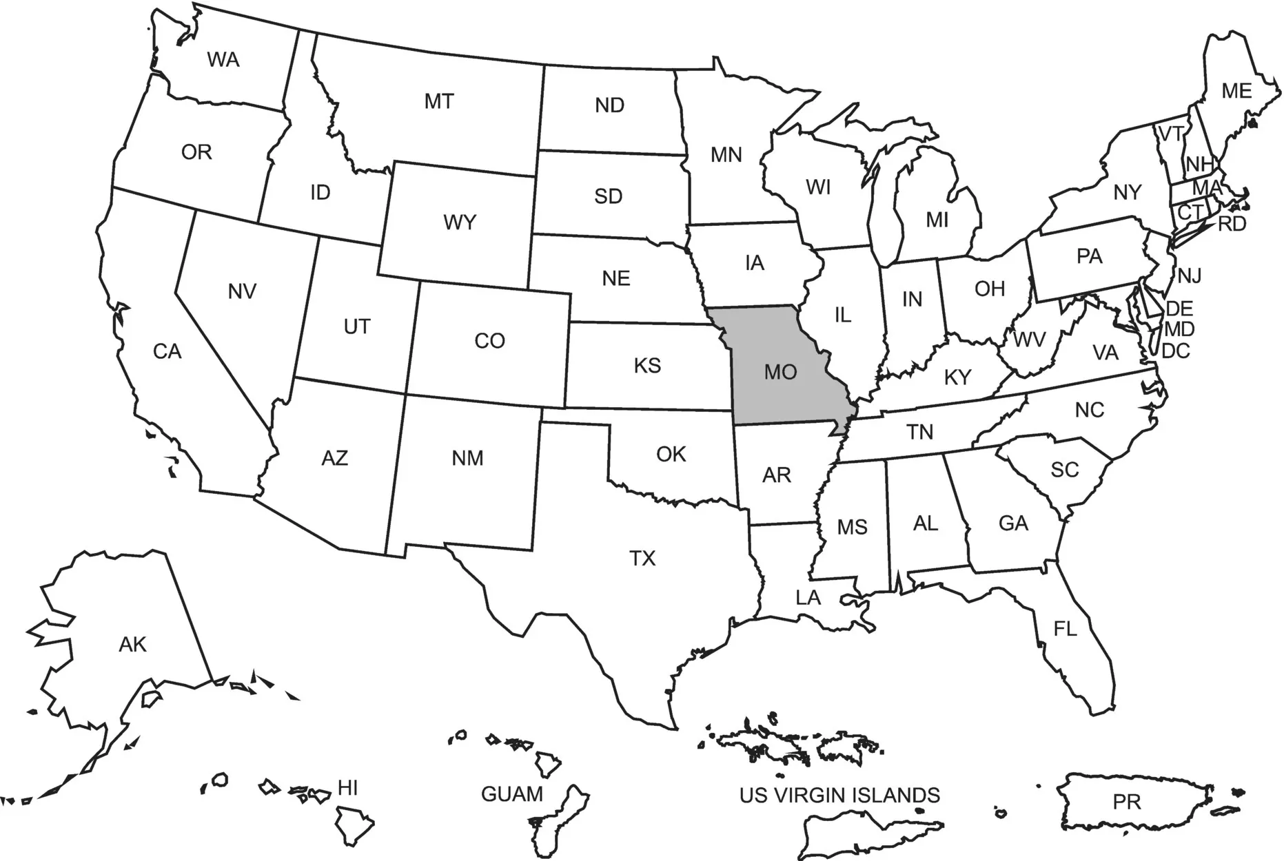
When Mark Twain's unforgettable character, Tom Sawyer, scolded Huckleberry Finn for thinking that Illinois was green and Indiana pink because each appeared that way on a map, Huck demanded, “What's a map for? Ain't it to learn you facts?” Although the illiterate Huck could not read a map, he knew its purpose. The map of the United States can teach numerous important geographic facts, many of which will increase one's understanding of Missouri history.
Mid‐America
Between the Appalachian Mountains in the east and the Rocky Mountains in the west is mid‐America. The continental interior contains a variety of physiographic factors such as a great inland water system formed by the Ohio, Mississippi, and Missouri Rivers and their 250 tributaries. These river basins give mid‐America its essential geographic unity.
Situated in the west north‐central part of mid‐America, the state of Missouri lies somewhat east of the geographical center of the United States. Between 36° and 40° 35′ north latitude and 89° and 95° 42′ west longitude, Missouri's total area of 69,686 mi2 makes it nineteenth in size among the states. It is one of only two states bordered by eight other states: Illinois, Kentucky, and Tennessee on the east; Arkansas on the south; Oklahoma, Kansas, and Nebraska on the west; and Iowa on the north.
East of Missouri are interior lowlands, dissected plateaus, and coastal plains. The Great Lakes of North America form a large drainage basin and connect to the Atlantic Ocean through the St. Lawrence River. Another major feature of this area is the Appalachian Highlands, which extend north–south for nearly 1500 mi from the island of Newfoundland into the state of Alabama. The mountain range is considered the geographical divide between the Atlantic seaboard and the American heartland. No other phrase so accurately denotes the place of Missouri in the United States as the one inspired by the great arch that rises above the Mississippi River at St. Louis – the “Gateway to the West.”
Figure 1.1 Map of United States with Missouri.
West of Missouri appear more diverse landscapes. Encompassing over half the land area of the United States, the American West begins with the Great Plains and continues north to the Canadian border, south to the Rio Grande, and west across the Rocky Mountains. The prairies stretch broadly to the foot of the Rocky Mountains, which extend north–south for more than 3000 mi from British Columbia into New Mexico. Beyond the “backbone” of the continent are rivers, plateaus, mesas, basins, deserts, mountains, canyons, forests, and grasslands. Not too distant looms the coastline of the Pacific Ocean.
The Mississippi River
The Mississippi River forms all but 20 mi of the eastern boundary that shapes the state of Missouri. It flows 2350 mi through the continent from Lake Itasca to the Gulf of Mexico. The upper Mississippi travels through a great valley with high ground and prominent bluffs on both banks. The bluff tops between Louisiana and Clarksville in northeast Missouri are among the highest along the river. When it reaches Cape Girardeau, the river widens, emerging from the wooded terrain and limestone cliffs to shape the Mississippi flood plains that stretch to the Gulf.
The Mississippi acquired its name from the Algonquin term “Misi‐ziibi,” which means the Great River. People often translated it with the reverent phrase “Father of Waters.” Awed by its size, various indigenous populations depended upon the waterway for survival. Its changing currents, sand bars, ice, flooding in low‐lying areas, submerged debris, and driftwood have made the river dangerous to both travelers and inhabitants. Explorers and traders walked its banks in search of wealth. Generations of farmers attempted to cultivate the fertile lands along the river bottom. As the Mississippi has evolved over the ages, it has always been an important force in the history of the continent.
From 1763 to 1783, the Mississippi divided the empires of Great Britain and Spain in North America. It became the western boundary of the newly established United States, yet it remained a trade route for many Natives and strangers alike. Questions over its navigation and the use of the Port of New Orleans for American products led to controversy between the United States and Spain, and later France, eventually resulting in the Louisiana Purchase of 1803. Before the Civil War, enslaved African Americans saw “upriver” as the way to freedom, while to be sold “downriver” meant bondage and the loss of hope. During the Civil War, Union forces fought to control the natural highway and to divide the slaveholding states. In time this strategy was decisive in the collapse of the Confederacy. Influenced by their river experiences, many artists, authors, folklorists, composers, and musicians have greatly enriched the cultural history of the American people. The Missourian known popularly as Mark Twain grew up on the Mississippi's banks at Hannibal, piloted a steamboat to earn a living, and used it as a setting for three of his best‐known books. He described it as “the crookedest river in the world, since in one part of its journey it used up one thousand three miles to cover the same ground that the crow would fly over in six hundred and sixty five.”
The Missouri River
The state's most distinctive geographical feature is the Missouri River. From its headwaters high in the northern Rockies to its confluence with the Mississippi, it flows 2714 mi, making it the longest river in the United States. Joined by northern and southern tributaries as it moves across Montana and North Dakota, it increases in volume and current. Running through rocky areas, which serve as a natural filter, the water remains clear. Once it washes into the grassy plains of the Dakotas, however, it begins to assume a muddy color. Following a course predetermined by large polar ice masses during the Ice Age, it continues in a southerly direction until it joins the Kansas River at Kansas City. There it bends and meanders 577 mi across the state to join the Mississippi 17 mi above St. Louis.
During the seventeenth century, Algonquin‐speakers usually called the river “Pekitanoui.” Though later dropped from usage, it means “muddy waters.” When Father Jacques Marquette and Louis Jolliet encountered the rushing water for the first time in 1673, they observed that the river was “all muddy.” One of the most difficult tasks for newcomers was navigating the charging current, which moved sandbars and eroded banks. Illini guides for early French visitors referred to the indigenous towns near the river as “mishoori” or “wemihsoori.” Their reference to “Mi‐`zor‐ä” suggests an Algonquin term for people with “dugout canoes” or “wooden canoes.”
The Missouri's major tributaries in the state are the Little Platte, Grand, and Chariton Rivers to the north and the Lamine, Osage, and Gasconade Rivers to the south. Although relatively short, these tributaries provide considerably more water than the plains tributaries and cause the river to widen and to pick up current speed. Because the Missouri fluctuates in its current more than the Mississippi, it frequently has changed its channel while washing away shorelines, farms, and even towns. Missourians often call the river “Big Muddy,” and to this day they say unceremoniously that it is “too thick to drink and too thin to plow.”
The brownish coloration of the water is due to the great amount of silt and solid matter carried by the Missouri. It is estimated that the river dumps 500 million tons of solid matter into the Mississippi annually. Present‐day ecological concerns dictate that more should be done to reduce the stream pollution and to conserve the wildlife once so abundant along its shores. The river meanders from bluff to bluff across the state, inspiring commonplace references to the “Wide Missouri.”
The Lay of the Land
During the Ice Age thousands of years ago, great mountains of ice ground into the terrain that would make the state of Missouri and then receded, leaving behind a land composed of four physiographic regions. North of the Missouri River is the Glacial Plains. Here the glaciers left behind rolling hills, gentle valleys, some rock formations of limestone and sandstone, and prairie earth similar to that of Iowa and Illinois. In addition to the glaciers, powerful winds carried a sediment known as loess and deposited it across the land, adding to the uniform texture and fertility of the soil. This region provides some of the state's most productive farmland.
South and southeast of the Missouri River is the Ozark Plateau or Highlands, which extend from Illinois into southern Missouri, Arkansas, Kansas, and Oklahoma. Located a few hundred miles southeast of the center of the United States, the Ozarks is a land of rocky hills, deep valleys, knobs, cliffs, tablelands, springs, and forests. The elevation ranges from 1200 to 1700 ft above sea level. Taum Sauk Mountain in Iron County, rising 1772 ft above sea level, is the highest point in the state. It may have been named for a term used by Algonquin‐speakers to suggest “big” or “outlet.” Others claim that the name refers to a legendary chief, Sauk‐Ton‐Qua. The soil of the Ozarks is not as fertile as that of the Glacial Plains because of a compact siliceous rock called chert, but trees abound on the undulant surface.
The name Ozarks is from aux arcs, a French abbreviation indicating “to the Arkansas Post” – an outpost established on the Arkansas River when the French first arrived in the Mississippi Valley. Wild rivers such as the Meramec, Black, White, Big Niangua, and Current run through the region, creating places of rugged beauty. The headwaters of some of these rivers are freshwater springs, from many of which flow over a million gallons a day. Big Springs in Carter County has a daily measured flow of 840 million gallons. Saline springs and salt licks are numerous in the region. During the twentieth century, the building of the Bagnell Dam across the Osage River formed a serpentine reservoir called the Lake of the Ozarks. Fishing spots and tourist resorts eventually sprouted along the 1300 mi of shoreline. Many Missourians today believe that the region's waterways, forests, caves, springs, and scenic landscapes are among the state's most precious resources.
Figure 1.2 Lake of the Ozarks Sunset, State Historical Society of Missouri.
In the western part of the state are the Osage Plains, a triangular area extending from a point in Pettis County southwesterly and turning into the Great Plains. The twisting Osage River is formed by the confluence of the Little Osage and the Marais des Cygnes Rivers, which places its headwaters in Kansas. Whereas the brown or gray soils in the wat...
Table of contents
Cover
Table of Contents
Preface to the Fourth Edition
About the Companion Website
1 Native Ground
2 A Confluence of Empires
3 The Missouri Borderlands
4 Statehood and Beyond
5 The Age of Benton
6 Slavery in Missouri
7 A Developing State
8 Turmoil on the Border
9 The Civil War
10 Radical Rule
11 The Gilded Age
12 Angry Farmers and Urban Reformers
13 Missouriana
14 Out of the Mud
15 The Pendergast Era
16 Better Government in Missouri
17 A Bellwether State
18 Into the New Millennium
Appendix
List of Illustrations
Index
End User License Agreement
Frequently asked questions
Yes, you can cancel anytime from the Subscription tab in your account settings on the Perlego website. Your subscription will stay active until the end of your current billing period. Learn how to cancel your subscription
No, books cannot be downloaded as external files, such as PDFs, for use outside of Perlego. However, you can download books within the Perlego app for offline reading on mobile or tablet. Learn how to download books offline
Perlego offers two plans: Essential and Complete
Essential is ideal for learners and professionals who enjoy exploring a wide range of subjects. Access the Essential Library with 800,000+ trusted titles and best-sellers across business, personal growth, and the humanities. Includes unlimited reading time and Standard Read Aloud voice.
Complete: Perfect for advanced learners and researchers needing full, unrestricted access. Unlock 1.5M+ books across hundreds of subjects, including academic and specialized titles. The Complete Plan also includes advanced features like Premium Read Aloud and Research Assistant.
Both plans are available with monthly, semester, or annual billing cycles.
We are an online textbook subscription service, where you can get access to an entire online library for less than the price of a single book per month. With over 1.5 million books across 990+ topics, we’ve got you covered! Learn about our mission
Look out for the read-aloud symbol on your next book to see if you can listen to it. The read-aloud tool reads text aloud for you, highlighting the text as it is being read. You can pause it, speed it up and slow it down. Learn more about Read Aloud
Yes! You can use the Perlego app on both iOS and Android devices to read anytime, anywhere — even offline. Perfect for commutes or when you’re on the go. Please note we cannot support devices running on iOS 13 and Android 7 or earlier. Learn more about using the app
Yes, you can access Missouri by William E. Parrish,Lawrence O. Christensen,Brad D. Lookingbill in PDF and/or ePUB format, as well as other popular books in History & North American History. We have over 1.5 million books available in our catalogue for you to explore.