![]()
1
Continent–Sea Interface: a Hydrogeological Continuum
The section of land between continent and ocean is the hydrogeological continuum. Geological reservoirs containing groundwater resources do not stop at the shoreline. These formations are continuous and may be covered by less permeable formations on the continental shelf. This interface on the coast takes the form of a transition zone between freshwater and saltwater due to the difference in density, the geometry of aquifers and the heterogeneity of their physical properties as well as how the coastal aquifers are used (supply of drinking water, agriculture, tourism, industry, etc.) and also, as freshwater inputs into the ocean. The proper management of coastal aquifers inevitably involves the risk assessment of saltwater intrusion, based on geological and hydrogeological knowledge of formations, observation and alert networks, management models integrating geological, hydrogeological and geophysical data and technical management solutions. Using methods to characterize clastic sedimentary geological reservoirs by sequential stratigraphy and seismic stratigraphy both onshore and offshore, respectively, helps suggest appropriate management tools for coastal aquifers that develop within sedimentary basins. In addition, characterizing the paleo-geographic evolution of the development of carbonate platforms over the course of geological time associated with the changes in sea level and vertical tectonic movements is essential in order to establish conceptual models required for monitoring and managing karstic coastal aquifers. Airborne geophysics provides information about the structure and intrusion of saltwater in formations, both sedimentary and volcanic. Different examples of coastal aquifers, primarily Mediterranean, show the specificity of this continuum, characterization and monitoring tools as well as management tools.
1.1. Introduction
Coastal zones form an interface between the land and the sea surface. Underground, coastal aquifers in turn form a hydrogeological continuum, an interface between the ocean and continent. Groundwater flows in geological formations, usually perpendicular to the coastline, toward continental and marine outlets on the continental shelf with the release of groundwater or occasionally underwater sources.
Groundwater is found in a variety of geological formations, between the sea and land: in detrital sedimentary formations (deltas, sedimentary basins, alluviums, etc.), in karstified limestone formations (Mediterranean, Mexico, Florida, etc.), bedrock formations (Britain, Scotland, Scandinavia, etc.) or volcanic formations (Reunion, Mayotte, Caribbean, Canaries, Azores, etc.). This space between the continent and ocean is an interface between salt and freshwater. Saltwater can penetrate the continent depending on natural conditions and abstractive conditions. As its density is higher than that of freshwater, it forms below freshwater, which we call a saltwater intrusion (theoretical abrupt interface) or a transition zone (diffuse interface).
This continent–ocean interface is a zone of interest both for human societies, with more than 60% of the world’s population living on the coastline less than 60 km wide, and for lagoon and marine ecosystems. This coastal zone attracts populations and tourists, both due to climatic conditions and quality of life as well as economic development (sea transport, import–export). Water resources are necessary for the development of this zone. Groundwater in aquifers of this sea–land continuum is an important source both for the supply of drinking water and for human activities (agriculture, industry, tourism, etc.). Specific ecosystems develop in the ocean or in lagoons next to groundwater outlets and may also be zones of economic interest (fishing, oyster farming, fish farming, etc.).
The Mediterranean basin and the French overseas islands are ideal for illustrating this continent–ocean interface. Three types of geological land–sea continuums are presented: sedimentary basin, karst and volcanic islands, as well as a description of the characteristics of the saltwater–freshwater interface for different geological contexts. Characterization tools, mainly geological, hydrogeological and geophysical, as well as the management of groundwater resources at this interface are also detailed.
1.2. Land–sea interface: from geology to the hydrogeological continuum
The land–sea interface covers 2 million kilometers of shoreline worldwide, distributed around different continents and numerous islands. Coastal zones, carbonate, volcanic (in the absence of lagoons) or bedrock, are steep except in large depressions associated with the main river basins, where large low-altitude areas occur: Rhine (Netherlands), Rhône, Garonne (France), Thames (United Kingdom), Vistula (Poland), Danube (Ukraine/Romania), Ebro, Guadalquivir (Spain) in Europe, for example.
Recent geological phenomena, such as glaciation and formation of reliefs, which effect sedimentary deposits and eustatic variations, have influenced the development of coastal aquifers occurring in the continent–ocean interface. During the last glaciation (≈ –18,000 years), a large part of the continents was covered with ice. Valleys were cut into rocky formations and ancient marine sediments, and then filled with fluvioglacial, fluvial, estuary, marine or even wind sediments. The Messinian salinity crisis in the Miocene (–5.95 to –5.3 million years) in the Mediterranean, isolating it from the Atlantic Ocean, significantly decreased sea level (up to 1,500 m) accompanied by salt deposits and the incision of deep valleys and karstic network development within carbonate massifs. These valleys were filled as the sea level rose with sediments, including clays and marls.
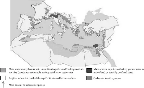
Figure 1.1 illustrates the position of the main alluvial and karstic carbonate aquifers, with the presence of the main submarine springs in the Mediterranean basin [AUR 08]. The flow rate of groundwater discharge into the Mediterranean Sea is, on average, estimated to be 43.5 km3/year (29 km3/year northern shore, 14 km3/year eastern shore and 0.5 km3/year southern shore), 10 times less than the discharge from surface water [MAR 08].
1.2.1. The continent–ocean continuum
The continent–ocean continuum is described by considering two representative cases: sedimentary basins or deltas and carbonate platforms.
1.2.1.1. Sedimentary basins or deltas
Mediterranean coastal sedimentary basins are good examples to show this type of continuum. Mediterranean coastal aquifers in sedimentary basins are found in Italy in the Pô plain, in Egypt with the Nile delta, in France with the Camargue plain in the Rhône delta and, to a lesser extent, along the coast of Languedoc-Roussillon from the Vistrenque plain to the Roussillon plain, all associated with the same evolution of the shelf of the Gulf of Lion and finally in Spain, with the Llobregat delta (Barcelona) or even the Ebro delta.
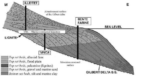
The geometry and three-dimensional (3D) field of hydrodynamic properties of aquifers and aquitards (semi-permeable) occur within sedimentary layers deposited over time. The occurrence of these formations can be explained using the Gilbert delta genetic model [DUV 08] (Figure 1.2).
As we pass from the Pliocene (–5.3 to –1.35 million years) to the Quaternary (–1.35 million years to present), sedimentary deposits, generated through the active erosion of watersheds situated upstream of deposition zones, prograde toward the center of the basin. At the base of the Gilbert delta, the sedimentary prisms are composed of silt and clay, from upstream to downstream. The top section of marine prisms is characterized by the presence of gravel and sand.
Marine prisms are overlaid by lacustrine layers and sediments from floodplains and alluvial fans. The sediment layers, which are deposited in the accommodation space in the basin, are influenced by erosion and transport of solids in the water as well as by sea level variations and vertical movements (subsidence in the basin, vertical movements associated with tectonics).
Restoring geometries of sedimentary layers is an important stage in the study of coastal aquifers occurring in alluvial depositions or sedimentary basins. Sequential or genetic strategy is an essential tool for analyzing the development of sedimentary layers along a land–sea continuum, using drilling data, observations of outcrops as well as geophysical data (seismic profiles). Sequential stratigraphy is defined as a method that defines a chronostratigraphic framework on a global scale based on accurate dating of time lines among discrepancies of eustatic origin (variation in sea level), which restrict genetic sediment units [VAI 91]. This method was applied to the Roussillon plain (South of France) [DUV 08, AUN 07] (Figures 1.3 and 1.4), and to the Llobregat delta (Spain) [GAM 09].
From a hydrogeological point of view, the Roussillon plain is a groundwater body subdivided into two vertical sections, namely the quaternary aquifer of a generally unconfined aquifer and confined aquifer if covered by impervious silt over 5 m deep in the coastal zone, composed of quaternary alluvial deposits and the deep Pliocene aquifer (Figure 1.5). The continental fluvial–lacustrine Pliocene deposits show superposition of permeable lenticular sandy layers within a less permeable clay matrix; the most permeable layers are located at the top of the prisms, along with arkosic sand. At the base of the continental pliocene deposits lies plastic clay, which forms the upper part of the marine pliocene deposits giving them a confined characteristic. The marine pliocene sediments partly composed of micaceous clays and silts are generally less permeable, but there are still local variations in characteristics, with lightly compacted sandy sections which form good aquifers. The base of the marine pliocene sediments, with blue marl, is impervious. Due to its architecture and geometry, this aquifer is heterogeneous: the hydraulic conductivity of different aquifer terrains as well as the position of the freshwater/saltwater interface can strongly vary [AUN 06]. Finally, the underlying aquifer is the sandy marine pliocene aquifer, separated from the continental Pliocene aquifer by layers of lignites and plastic clays resulting from depositional environments of flood plains or wet lands; these layers are not continuous throughout the area. The sandy marine pliocene aquifer develops within sediments of prograding prisms of the delta in the distal part of the basin. This aquifer, in theory, is not in direct contact with the sea; however, certain sections are affected by mineralization associated with chlorides. The origin of this mineralization is quite probably due to contamination from being hydraulically connected to the quaternary aquifer by defective boreholes. Without pumping, the hydraulic load of the sandy marine pliocene aquifer is greater than that of the continental pliocene aquifer [AUN 06].